|
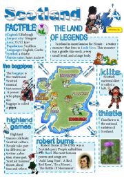
Scotland-info poster for young learners
A wall poster with basic information about Scotland.
Level: elementary
Age: 9-12
Type: worksheet
Downloads: 829
|
|
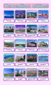
Canadian cities pictionary
20 most densely populated Canadian cities.
Level: intermediate
Age: 12-17
Type: worksheet
Downloads: 46
|
|
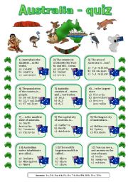
Australia quiz
A quiz about Australia. Answer key included.
Level: intermediate
Age: 12-17
Type: worksheet
Downloads: 164
|
|
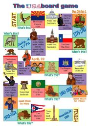
The USA board game 2
ANSWERS:
Animals (green squares): bald eagle-grizzly bear-coyote-prairie dog-groundhog-buffalo.
States (pink squares): Arizona-Texas-California-New York-Washington-Ohio.
Landmarks (yelow squares): the Capitol Building-Independence Hall-Rock and Roll Hall of Fame-Guggenheim Museum-Liberty Bell-San Jacinto Monument.
People (purple squares): Abrah...
Level: intermediate
Age: 12-17
Type: worksheet
Downloads: 164
|
|
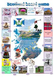
Scotland board game
A board game on Scotland. Answers: the UK-a thistle-loch-a bagpipe-Edinburgh-pound sterling-tartan-Glasgow-St. Andrew-Ben Nevis-golf-Nessie-Alexander Fleming-a piper-Unicorn-Highland-Alexander G. Bell-Hogmanay-whiskey-a kilt-Forth Bridge-haggis-5 million-Robert Burns
Level: elementary
Age: 9-12
Type: worksheet
Downloads: 86
|
|
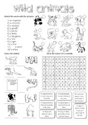
Wild animals-activities for young learners
Kids are to match the words with the pictures, guess the names of the animals looking at their body parts, do the wordsearch and guess the animals using the descriptions.
Level: elementary
Age: 7-10
Type: worksheet
Downloads: 252
|
|
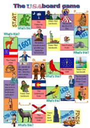
The USA board game 3
ANSWERS: Animals: alligator - armadillo - white-tailed deer - cardinal - goldfinch - bighorn sheep. States: South Carolina- Illinois-Georgia-Indiana-Colorado-Florida. Landmarks: the White House-the Statue of Liberty-the Golden Gate Bridge-the Liberty Bell-Sears Tower. People: Betsy Ross-Thomas Edison-Walt Disney-Henry Ford-Scott Carpenter. Indians:...
Level: intermediate
Age: 14-17
Type: worksheet
Downloads: 151
|
|
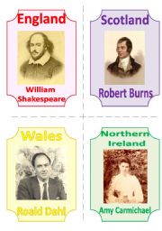
THE UK FLASHCARDS 5 - FAMOUS POETS (WRITERS), 1 page, fully editable
The fifth part of my set is dedicated to people who glorified their countries.
Level: intermediate
Age: 12-17
Type: flash-card
Downloads: 106
|
|
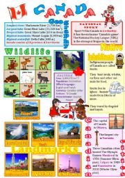
Canada wall poster
The 3rd part of the series - this time about Canada (its landmarks, native inhabitants, wildlife, cities...).
Level: intermediate
Age: 12-14
Type: worksheet
Downloads: 443
|
|
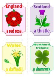
THE UK FLASHCARDS 1 - SYMBOLS and FLAGS, 2 pages, 8 cards
The first part of a set of flashcards about the UK (symbols and flags). Fully editable, so the names of the countries can be deleted and the cards can be used in various games (guess the country which this symbol/flag belong to...).
Level: intermediate
Age: 12-17
Type: flash-card
Downloads: 191
|